
Buildings and Blocks
Fourth and Nowhere
When the city issued its Request for Proposals on the World's Fair site in 2004, it organized public meetings to solicit input on the process and arranged for interested citizens to tour the subject buildings. Never having been inside the Sunsphere, I enthusiastically accepted the city's invitation and took the short elevator ride up into the ball.
The gold-tinted picture windows at the top provided a fine view of downtown. What I didn't expect was the view to the north, the maze of roadways and ramps making up the juncture of I-275 and I-40 that seemed equal in footprint to the entire central business district. Imagine an area the size of downtown Knoxville occupied by roadways, ramps and nothing else.
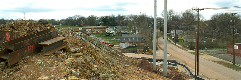
A look at an aerial map confirmed my eyeball estimate. Meandering through the maze at ground level is a unique experience. Drive over to Sutherland and University and check out the concrete wasteland, a surrealistic landscape devoid of human scale but of the kind found in most North American cities. While unfriendly, it isn't as scary as a roadway of similar size and scale built next to your house. Another look at the aerial map revealed that the site of SmartFIX40 - the Tennessee Department of Transportation (TDOT) brand name for its I-40 expansion through downtown - occupies a piece of land nearly the size of the entire Fourth and Gill historic neighborhood.
By federal law, public meetings had to be held in the design phase to solicit the opinions of residents living near the proposed construction. Dazzling maps and perspective drawings, accompanied by video screenings of computer-generated 'fly-by' animations, could not have prepared residents of the neighborhood for the stark reality of the built project. Peek out your back window and watch the Wal-Mart 18-wheelers zoom by at 75 mph. Where's the city's speed enforcement? Walk out your front door and face a faux-stone textured four-story-high concrete retaining wall, one of the 'mitigating' features added to the final contract. Step out into a garden bounded by a 'sound wall,' a precast feature of debatable acoustic effectiveness.
At a projected cost of $200 million when it is completed in 2009, the construction will be the state's most expensive in its history. The site runs close to one linear mile, includes 40 lane-miles, and occupies 173 acres (0.27 square miles). A marvel of modern engineering and fast-track programming, its stated purpose is to correct existing roadway deficiencies like inadequate ramps and lane widths, and improve traffic flow through downtown by adding drive lanes to match the standard of the already widened east and west segments.
The new standard is expected to satisfy functional needs twenty years in the future, through 2026. What will happen beyond that date is outside the parameters of the plan. Will the road need to be doubled in width again? Will vehicles be bigger or smaller than they are today? Will mass transportation begin to take over the task of moving people within the metropolitan area? Will design parameters thought safe become unsafe once more?
Another approach has been taken by cities eager to correct past planning mistakes and willing to consider the serious effect transportation design can have on the economic, social and environmental well-being of the community. Notable is the case of Boston which, in the 1980s, decided to move its Central Artery underground. An elevated highway completed in 1959, the Artery was notorious for its accident rate, traffic jams, and effect on historic neighborhoods cut off physically from the downtown. The massive excavation and reconstruction project that ensued, known as The Big Dig, was completed in 2005 at a cost of $14.6 billion.
While Boston, a state capitol, has six times the population of Knoxville, many of the issues facing both cities are the same. High speed roadways bring with them envelopes of air and sound pollution whose impact, TDOT admits, is "inexact science." The removal or burial of such roads enables cities to restore the contiguity of its older neighborhoods, significantly reduce pollution, and open huge inner-city parcels to new development.
When I forwarded a panoramic image of SmartFIX40 pushing its way through one of the oldest and most fragile residential neighborhoods in the city, a friend who is a principal consultant with one of the largest planning, engineering and construction management firms in the country, made the following comment: "Unbelievable. No one does this much more in the real world."
Knoxville, of course, is no less a part of the 'real world' than Boston, yet the latter has chosen the difficult, expensive, time-consuming approach that represents an optimistic investment in its future health and growth. Our city, on the other hand, chose a way that sacrifices air quality and noise levels to economies of execution, and forfeited the possibility of naturally stitching together its downtown with its oldest inner suburbs. Preventing future damage from new highways or the expansion of old ones - projects always on the transportation industry agenda - will require a smarter generation of planners and politicians and a more alert and activist citizenry.
©2007 Michael Kaplan. This article originally appeared in the Knoxville Voice.